
TRUE NORTH GEOPHYSICS
MARINE GEOPHYSICAL SERVICES

BATHYMETRY
We offer bathymetric surveying of the water bottom to support marine projects such as bridges, port facilities, marine construction projects, and for mining projects. Survey methods include single beam and multibeam bathymetric methods.

SIDESCAN SONAR
We offer sidescan sonar surveys to map objects on the water bottom, to classify the water bottom type, to identify archaeological features, and to map water bottom hazards that may pose risk to a project.

MAGNETOMETER
Marine magnetometer surveys can be carried out to map the presence of metallic objects that are exposed or buried beneath the water bottom. This can be important to locate archaeological features, map hazards such as pipelines. A marine magnetometer can also be useful to map geological features, such as fault zones and presence of mineralized zones in the subsurface.
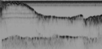
SUBBOTTOM PROFILING
We offer a full range of subbottom profiling, including high frequency to map shallow layers below the water bottom and low frequency to map depth to deeper layers such as bedrock and sedimentary layers. Subbottom profiling surveys are useful for marine projects to map the subsurface and a key step in any marine geotechnical project and when boreholes are costly or not possible in a marine setting.

MARINE SEISMIC SURVEYS
We carry out single channel and multichannel marine seismic reflection and refraction surveying in marine settings. This includes in transitional zones, such as river crossings, where subsurface information is critical for projects. Obtaining information on the seismic velocity of layers can also be useful to assess the strength of the different layers for engineering purposes.